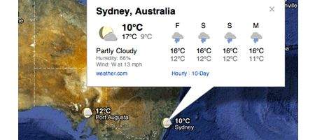
Google’s added a new layer to its Google Maps application, displaying current temperatures and conditions around the globe.

Through deals with the Weather Channel’s weather.com and the US Naval Research Laboratory, the new feature gives the current weather for each spot, as well as a four-day forecast. The NRL already provides weather data for Google Earth.
The weather layer can be added via the list of options in the upper right-hand corner of Google Maps. Different icons denote sun, rain and cloud coverage. Sun and moon icons show whether it’s day or night.
“Clicking on the weather icon for a particular city will open an info window with detailed data like current humidity and wind conditions, as well as a forecast for the next four days,” says user experience designer Jonah Jones.
It’s also possible to change the units of wind speed from miles per hour to kilometers per hour, and temperature can be shown in Farenheit or Celcius. If the clouds are getting in the way, they can be disabled.
The app competes with thousands of others, many of which show far more detailed information – including weather.com’s own, to which Google Maps links. It looks as if Google isn’t that serious about becoming a weather forecaster in its own right.


