Rising sea levels could threaten an average of nine percent of the land within 180 US coastal cities by 2100.
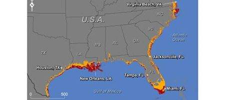
The Gulf and southern Atlantic coasts will be particularly hard hit, with Miami, New Orleans, Tampa and Virginia Beach losing more than 10 percent of their land area by 2100.
The research, led by University of Arizona scientists, is the first analysis of vulnerability to sea-level rise to include every US coastal city in the lower 48 with a population of 50,000 or more.
It’s based on the National Elevation Dataset produced by the US Geological Survey, which the team used to create detailed maps showing endangered land.
The latest scientific projections indicate that by 2100, the sea level will have risen by about a meter, and will thereafter rise by about one meter per century.
“With the current rate of greenhouse gas emissions, the projections are that the global average temperature will be eight degrees Fahrenheit warmer than present by 2100,” says lead researcher Jeremy Weiss.
“That amount of warming will likely lock us into at least four to six meters of sea-level rise in subsequent centuries, because parts of the Greenland and Antarctic ice sheets will slowly melt away like a block of ice on the sidewalk in the summertime.”
At three meters, on average more than 20 percent of land in affected cities could be underwater. Nine large cities, including Boston and New York, would have more than 10 percent of their current land area threatened. By six meters, about one-third of the land area in US coastal cities could be flooded.
“Our work should help people plan with more certainty and to make decisions about what level of sea-level rise, and by implication, what level of global warming, is acceptable to their communities and neighbors,” says co-author Jonathan T Overpeck.