Sea level rises are accelerating along parts of the US East Coast as much as four times faster than the average for the rest of the world.
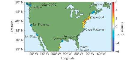
According to a new US Geological Survey report, sea-level rise in the 600-mile coastal zone from Cape Hatteras, NC, to north of Boston, Massachusetts, has increased by between two and 3.7 millimeters per year since about 1990. By contrast, the global increase over the same period was between 0.6 and 1.0 millimeters per year.
The researchers say that the sea-level rise hotspot is consistent with the slowing of Atlantic Ocean circulation. Models show that this change in circulation may be tied to changes in water temperature, salinity and density in the subpolar north Atlantic.
“Many people mistakenly think that the rate of sea level rise is the same everywhere as glaciers and ice caps melt, increasing the volume of ocean water – but other effects can be as large or larger than the so-called ‘eustatic’ rise,” says USGS director Marcia McNutt.
“As demonstrated in this study, regional oceanographic contributions must be taken into account in planning for what happens to coastal property.”
Over the rest of the century, the sea level rise in the hotspot is expected to be 8 to 11.4 inches, over and above the global sea level rise.
“Cities in the hotspot, like Norfolk, New York, and Boston already experience damaging floods during relatively low intensity storms,” says USGS oceanographer Dr Asbury Sallenger.
“Ongoing accelerated sea level rise in the hotspot will make coastal cities and surrounding areas increasingly vulnerable to flooding by adding to the height that storm surge and breaking waves reach on the coast.”