The same kind of information and visual depiction you’ve come to expect from Google when looking for a store or building will now go with you when you step inside said location.
Version 6.0 of the Google Maps Android app has just launched, and brings with it a new indoor mapping feature.
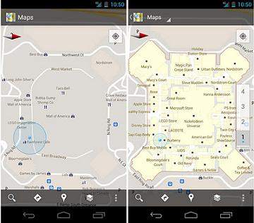
What exactly is indoor mapping? Well, for example, Google has taken information about the inside of Macy’s 34th Street location in New York City and mapped it so you can see where the men’s section is, where the fitting rooms are, etc.
The same kind of visual presentation is available for the San Francisco International Airport and Chicago O’Hare. In all, 25 locations around the country have been “indoor-mapped” and Google will continue to expand with other locations.
This feature not only gives you floorplans of the indoor spots but also actually tracks you with a proprietary indoor GPS feature.
“GPS is unreliable and doesn’t work well indoors. We used similar information to how we’ve implemented the navigation ‘blue dot’ feature in the past, and we’ve been able to improve the accuracy indoors, at an accuracy of about 5 to 10 meters,” explained Google Maps project manager Steve Lee in an interview quoted by CNN.
The process involves a human team actually going into each individual space and creating a map from scratch for that specific location. It’s not as easy as just driving a car with a mounted 365-degree camera like Google’s Street View feature.
So it’s limited for now, but it’s certainly an interesting project. The update is available from the Android Market for those running Android 2.1 or later.