There’s a pleasant pub in London’s Soho called the John Snow – and right outside stands the defunct water pump which Snow shut off when he realized that its water was giving the local residents cholera.
Snow had noticed that almost all the deaths in an 1894 outbreak of the disease were of people who used that pump rather than another. His ideas were teated with scorn at first, as it was generally believed that cholera was caused by an airborne ‘miasma’.
But realizing the true source of infection and shutting off the contaminated pump broght the outbreak to an end.
Now, scientists funded by the Wellcome Trust are attempting to do very much the same thing in Nepal, using Google Earth and gene sequencing technology to map the spread of typhoid and trace its source.
Typhoid fever is caused by two bacteria – Salmonella typhi and Salmonella paratyphi – which are generally spread through water or food contaminated with faeces.
But while recent advances in DNA sequencing have allowed scientists to accurately track the spread of some diseases by measuring mutations in the pathogen’s DNA when the DNA replicates, it’s proved impossible so far whewn it comes to cholera. There are few such mutations, and they’re simply undetectable by most current techniques.
And, when it comes to Kathmandu, there’s another problem: street names aren’t used in Nepal, making mapping the disease particularly difficult.
“Until now, it has been extremely difficult to study how organisms such as the typhoid-causing bacteria evolve and spread at a local level,” says Dr Stephen Baker from the Oxford University Clinical Research Unit in Vietnam.
“Without this information, our ability to understand the transmission of these diseases has been significantly hampered. Now, advances in technology have allowed us for the first time to create accurate geographical and genetic maps of the spread of typhoid and trace it back to its sources.”
Health workers visit patients’ homes and use GPS to capture the exact location. They also take blood samples to allow analysis of the typhoid strain’s genotype.
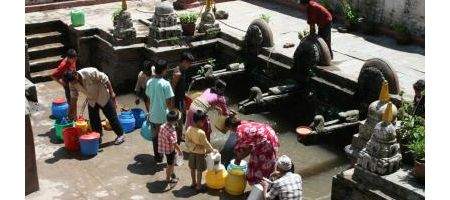
And, surprisingly, the researchers found extensive clustering of typhoid infections that was unrelated to local population density. Instead, people living near to water spouts and at a lower elevation are at by far the greatest risk of contracting the disease.
“Improvements in infrastructure are fundamental to the control and elimination of typhoid. Poor water quality, sanitary conditions and the presence of carriers mean that the organisms will persist in the community long after the limited window of immunity given by the current vaccine,” says Baker.
“Without integrating improvements in infrastructure alongside other control measures such as diagnosis, treatment and vaccination, it is unlikely that typhoid can be adequately controlled in places like Kathmandu in the long-term.”