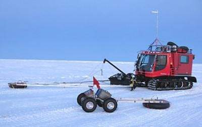
If you need help in snow and ice, who better to ask for help than a yeti?

National Science Foundation-funded researchers are now using a self-guided robot, named for the abominable snowman, that uses ground-penetrating radar to map deadly, hidden crevasses. It could make Arctic and Antarctic explorations safer for crews that supply remote scientific research stations.
Crevasses often can span widths of 30 feet or more, and be as much as 200 feet deep – and they’re often impossible to spot by eye, as snow can accumulate and cover them.
Currently, crevasses are detected by a vehicle pushing a ground penetration radar unit – dangerous and stressful for the crews, especially when traversing long distances.
“Polar exploration is not unlike space missions; we put people into the field where it is expensive and it is dangerous to do science,” says James Lever of the the US Army’s Cold Regions Research and Engineering Laboratory (CRREL).
“Our focus with Yeti is on improving operational efficiency. But more generally, robotics has the potential to produce more science with more spatial and temporal coverage for less money. We’re not gong to replace the scientists. But what we can do is extend their reach and add to the science mission.”
Yeti is a 180-pound battery powered, four-wheel drive vehicle, about a meter across, that can operate in temperatures as low as -20 Fahrenheit. It uses GPS coordinates to navigate and to plot the position of under-ice hazards, replacing human crews using ground-penetrating radar.
It’s successfully deat with Greenland’s Inland Traverse, an over-ice supply train from Thule in the north of Greenland to NSF’s Summit Station on the ice cap, as well as NSF’s South Pole Traverse – a 1,031-mile, over-ice trek from McMurdo Station in Antarctica to the South Pole.
And Yeti is even working to make itself redundant. The researchers say they’re using the data gathered by Yeti to refine algorithms that will allow machines in future to automatically map and avoid crevasses on their own.


