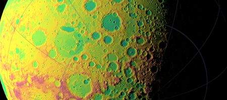
NASA is working on a topographic map of the moon showing its mysterious dark side in greater detail than ever before.

The data’s been collected by the Lunar Orbiter Laser Altimeter (LOLA), whose five beams create a two-dimensional map that unambiguously reveals slopes. LOLA will also measure the spreading of the return pulse and the change in its energy to establish the surface roughness and reflectance.
It uses about three billion range measurements so far, compared to about eight million to nine million each from three recent international lunar missions.
“After about one year taking data, we already have nearly 3 billion data points from the Lunar Orbiter Laser Altimeter on board the LRO spacecraft, with near-uniform longitudinal coverage,” says said Dr Gregory Neumann of NASA’s Goddard Space Flight Center.
“We expect to continue to make measurements at this rate through the next two years of the science phase of the mission and beyond. Near the poles, we expect to provide near-GPS-like navigational capability as coverage is denser due to the spacecraft’s polar orbit.”
Until now, the far side of the moon has been mapped only with an accuracy of up to ten kilometers. But the new observations have an accuracy of 30 meters horizontally and just one meter vertically. Neumann says that at the poles, where illumination is poor, his team found systematic horizontal errors of hundreds of meters.
“Until LRO and the recent Japanese Kaguya mission, we had no idea of what the extremes of polar crater slopes were,” said Neumann.
“Now, we find slopes of 36 degrees over several kilometers (several thousands of yards) in Shackleton crater, for example, which would make traverses quite difficult and apparently causes landslides.”


